Update 5:00 p.m. May 11, 2024
The RMWB and Alberta Wildfire are responding to a wildfire in the Gregoire area near the Petro Canada along Highway 63.
Harvard Media News will update with more information as it becomes available.
Update 3:20 p.m. May 11, 2024
The RMWB has issued an Evacuation Alert for Gregoire Lake Estates, Fort McMurray 468 First Nation, and Anzac. This alert is in addition to the alert in place for Fort McMurray and Saprae Creek.
The fire remains 16 km south of Fort McMurray. The RMWB and Province stress that these are evacuation alerts and not evacuation orders.
The alert is to advise residents to be prepared to leave on short notice.
The list of all communities under alert is:
- Fort McMurray
- Saprae Creek
- Anzac
- Fort McMurray First Nation #468
- Gregoire Lake Estates
- Rickards Landing Industrial Park
Update 2:30 p.m., May 11, 2024
Warm temperatures and high winds are continuing to cause fire MWF-017 to grow. While Alberta Wildfire continues to fight the 1,492 hectare blaze, they are anticipating Highway 63 to be affected by the highway later today.
In an update by the RMWB, the municipality says they are anticipating a temporary closure of Highway 63 south of the Highway 63 and 881 junction. They expect Highway 881 to remain open at this time.
RCMP are the lead agency to communicate any highway impacts or closures. The RMWB advises checking Alberta 511 for up to date information.
______
Update: 11:00 a.m. May 11, 2024
Alberta Wildfire is reporting fire MWF-017 remains 16 km from Fort McMurray and has grown to 1,492 hectares, or 14.92 square kilometers in size.
They continue to fight the fire using five wildland firefighting units, nine helicopters, and waterbombers. Heavy equipment is also engaged in building a fireguard on the east flank of the blaze.
Authorities are expecting fire behavior to intensify due to strong winds.
The evacuation alert remains in place for Fort McMurray and Saprae Creek, and a fire restriction remains in place over the Fort McMurray Forest Area.
The current fire danger for our region is rated extreme.
______
Update: 8:30 a.m. May 11, 2024
Fort McMurray and Saprae Creek remain under an evacuation alert. The Regional Municipality of Wood Buffalo (RMWB) advises that this alert is not an evacuation order. Under this alert, residents should:
– Monitor rmwb.ca/alerts for evacuation updates
– Stay informed via official and reliable sources like www.alberta.ca/wildfire-status
– Utilize the Alberta Emergency Alerts App
– Follow local media outlets
– Establish communication with neighbors for emergency notifications
– Prepare an emergency kit and plan for their household
Aerial operations, including night vision helicopter flights, continued overnight, resulting in subdued fire and smoke activity due to cooler temperatures and favorable winds.
Alberta Wildfire reports the fire’s location as 16 kilometers southwest of Fort McMurray, spanning 1,000 hectares. This morning, northwest winds propelled the fire east-southeastward.
In addition to helicopters and water-bombing aircraft, heavy machinery has been deployed on the ground against the fire. With rising temperatures anticipated this afternoon, fire activity is expected to escalate. Currently, Highway 63 remains unaffected, but smoke visibility is being closely monitored.
For highway updates, refer to Alberta 511.
_____
Update: 8:30 p.m. May 10, 2024
Regional fire Chief Jody Butz said Friday that the wildfire (MWF 017) burning just 16 kilometers from Fort McMurray is being pushed away from the urban area, including Saprae Creek.
The Regional Municipality of Wood Buffalo held a news conference shortly after 7:30 p.m. to provide an update on the situation with the nearby wildfire and evacuation alert. According to Chief Jody Butz, Fort McMurray and Saprae Creek are not at risk from the fire. “The evacuation alert is being issued out of an abundance of caution and in case the situation changes,” Butz said. “Wind is pushing the fire away from the communities, and we continue to monitor the situation closely.”
The RMWB is working with their provincial counterparts at Alberta Wildfire to stay apprised of the ongoing situation. Both the RMWB and Alberta Wildfire are paying close attention to Highway 63 south of Fort McMurray.
“There are concerns over the risk to Highway 63 south,” Butz said. “The visibility on the highway remains good, but the fire is showing extreme fire behavior.”
The fire weather forecast from Alberta Wildfire predicts a cold front to pass over the Fort McMurray region around midnight, something Butz says should improve the situation.
“We expect the situation to look much better Saturday morning,” Chief Butz added.
Between Fort McMurray and MWF 017 lies a large section of forest burned during the 2016 Horse River fire, but Butz said this will not serve as a barrier, as grass and other vegetation have grown since the blaze.
“There is less fuel in the area, so we would not expect a big crown fire. However, we know from experience that fires can still be sustained in the older burned areas,” Butz said.
The chief stressed that Fort McMurray and Saprae Creek are not currently at risk from the nearby fire. However, should the situation change, Butz has confidence in the community and the authorities to keep everyone safe.
_____
Update: 7:30 p.m. May 10, 2024: The wildfire burning 25 km southwest of Fort McMurray has grown to 1,000 hectares in size as air and ground crews from Alberta Wildfire continue to battle the blaze.
_____
Update 6:40 p.m. May 10, 2024: Evacuation Alert for Fort McMurray and Saprae Creek (MWF-017 Fire)
The Regional Municipality of Wood Buffalo has issued an evacuation alert for Fort McMurray and Saprae Creek Estates due to the MWF-017 wildfire burning southwest of Fort McMurray. The fire is currently 25 KM southwest of Fort McMurray, and smoke could impact visibility on Highway 63 south of Fort McMurray.
- At this time an evacuation order has not been issued
- This is an alert for residents in the effected area to be ready to evacuate on short notice
- Keep essential items like medications, important documents, and emergency kits ready for quick departure
- Stay informed by following official Alberta Emergency Alerts, Alberta Wildfire App, RMWB social media and the RMWB website.
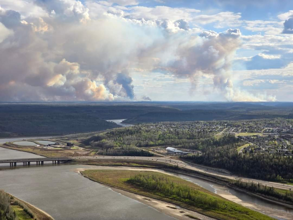
A large plume of smoke is visible from Fort McMurray due to a wildfire approximately 25 from town.
Alberta Wildfire says a 100-hectare wildfire is burning about 25 km southwest of Fort McMurray and 10 km east of Grand Rapids. The fire began on Thursday and has grown in size due to high winds and dry conditions.
There are four crews of wildland firefighters, three helicopters, and airtankers battling the blaze. The province will also have three night vision helicopters actioning the fire overnight. A spokesperson with Alberta Wildfire says a cold front is expected to move through the Fort McMurray region near midnight, which will help with the fire effort.
The current fire danger in the Fort McMurray Forest Area is considered extreme, and the province is urging the public to exercise caution while outdoors.


